

In recent years, the waters of the northern Arabian Gulf have not been as calm as they appear on the surface. Beneath them lie unresolved geopolitical and historical entanglements that have never truly been settled.
By February 2026, a complex diplomatic crisis between the neighboring states of Iraq and Kuwait had taken center stage in the regional arena. The trigger was a technical step taken by Baghdad regarding maritime boundary demarcation one with profound sovereign implications that Kuwait interpreted as crossing established lines.
So what exactly is the origin of the dispute? Why has it flared up now? Which areas and sites are involved, and what is their actual scale on the map? And how has Khor Abdullah, time and again, shifted from a navigational channel to the epicenter of tension between Baghdad and Kuwait?
The Return of the Crisis
The contours of the current crisis began to emerge when Iraq submitted updated lists of geographic coordinates and an explanatory map delineating its maritime domains to the UN secretary-general on January 19 and February 9, 2026.
Baghdad based its move on the 1982 United Nations Convention on the Law of the Sea, specifically relying on the World Geodetic System (WGS-84), to draw straight baselines and define its territorial sea, contiguous zone, exclusive economic zone, and continental shelf.
The Iraqi Foreign Ministry stated that this submission supersedes previous filings from 2011 and 2021 and is intended to safeguard Iraq’s sovereign rights and strengthen its legal position in any future negotiations over maritime boundaries particularly in the area beyond buoy 162 in Khor Abdullah.
Kuwait objected to the Iraqi filing, describing it as an infringement on its sovereignty over certain maritime areas and fixed shoals, such as Fasht Al-Aij and Fasht Al-Qaid, which it considers integral and non-negotiable parts of its territory.
Accordingly, the Kuwaiti Foreign Ministry summoned Iraq’s chargé d’affaires and delivered an official note of protest, asserting that the Iraqi maps contained claims infringing upon Kuwaiti sovereignty.
Kuwait said Iraq’s new map includes areas covered by the Khor Abdullah Agreement signed by both sides in 2012 and ratified by the Iraqi parliament in 2013. Reintroducing these areas as “Iraqi zones,” it argued, implicitly casts doubt on the understandings that have governed navigation in the channel.
Kuwait maintains that the targeted shoals were never historically disputed and that any attempt to alter the status quo undermines trust between neighbors and raises legal concerns about Iraq’s adherence to agreements registered with the United Nations.
The Historical Roots of the Dispute
The origins of the conflict date back to Kuwait’s independence in 1961, when successive Iraqi governments initially refused to fully recognize it. That stance shifted in 1963, when the two countries exchanged letters in which Baghdad recognized Kuwait’s independence, albeit with understandings concerning the boundary line in Khor Abdullah.
Following Iraq’s invasion of Kuwait in 1990 and its liberation in 1991, the UN Security Council intervened to demarcate the land boundary through Resolution 833 in 1993. The UN Boundary Demarcation Commission recommended dividing Khor Abdullah equally between Kuwait and Iraq, based on the 1963 correspondence.
However, the commission stopped at point (or buoy) 162 at the mouth of the channel, leaving the maritime boundary in the Gulf to be settled bilaterally.
Kuwait welcomed the resolution as affirming its historical claims, while some Iraqis argued that the United Nations had exploited Baghdad’s postwar weakness to cede territory to Kuwait.
After the fall of Saddam Hussein’s regime in 2003, relations gradually improved. The two governments reopened the maritime boundary file, and in April 2012 then–Iraqi Prime Minister Nouri al-Maliki signed an agreement regulating navigation in Khor Abdullah, aimed at managing the channel and organizing dredging operations.
The Iraqi parliament ratified the agreement in 2013, and it was registered with the United Nations as a binding international treaty. However, Iraqi politicians particularly from the sout considered it a concession of sovereignty and argued that the ratification process failed to secure the constitutionally required majority, fueling mounting controversy.
That tension reached its peak in September 2023, when Iraq’s Federal Supreme Court issued a ruling that sent political shockwaves and provoked anger in Kuwait. The court invalidated parliament’s ratification of the agreement, citing a procedural constitutional flaw: the ratification law had not obtained a two-thirds majority.
The decision stripped the bilateral understandings of their domestic legal cover and effectively paved the way for Baghdad to move unilaterally by depositing its new maps an unmistakable challenge to Kuwait’s insistence on the sanctity of the annulled agreement.
The Iraqi–Kuwaiti Joint Technical and Legal Committee held its tenth round in July 2025 to discuss points beyond buoy 162, signaling a willingness to address the issue through technical frameworks. Yet populist rhetoric persisted. Lawmakers from Basra described navigational concessions as “humiliating,” and some linked the issue to another dispute over the shared Al-Durra gas field, claimed by Kuwait and Saudi Arabia in the face of Iranian demands for a share. Iraqi lawmakers have questioned whether Baghdad stands to benefit from the field.
Additional Factors Fueling the Dispute
1. Port Projects and Economic Rivalry
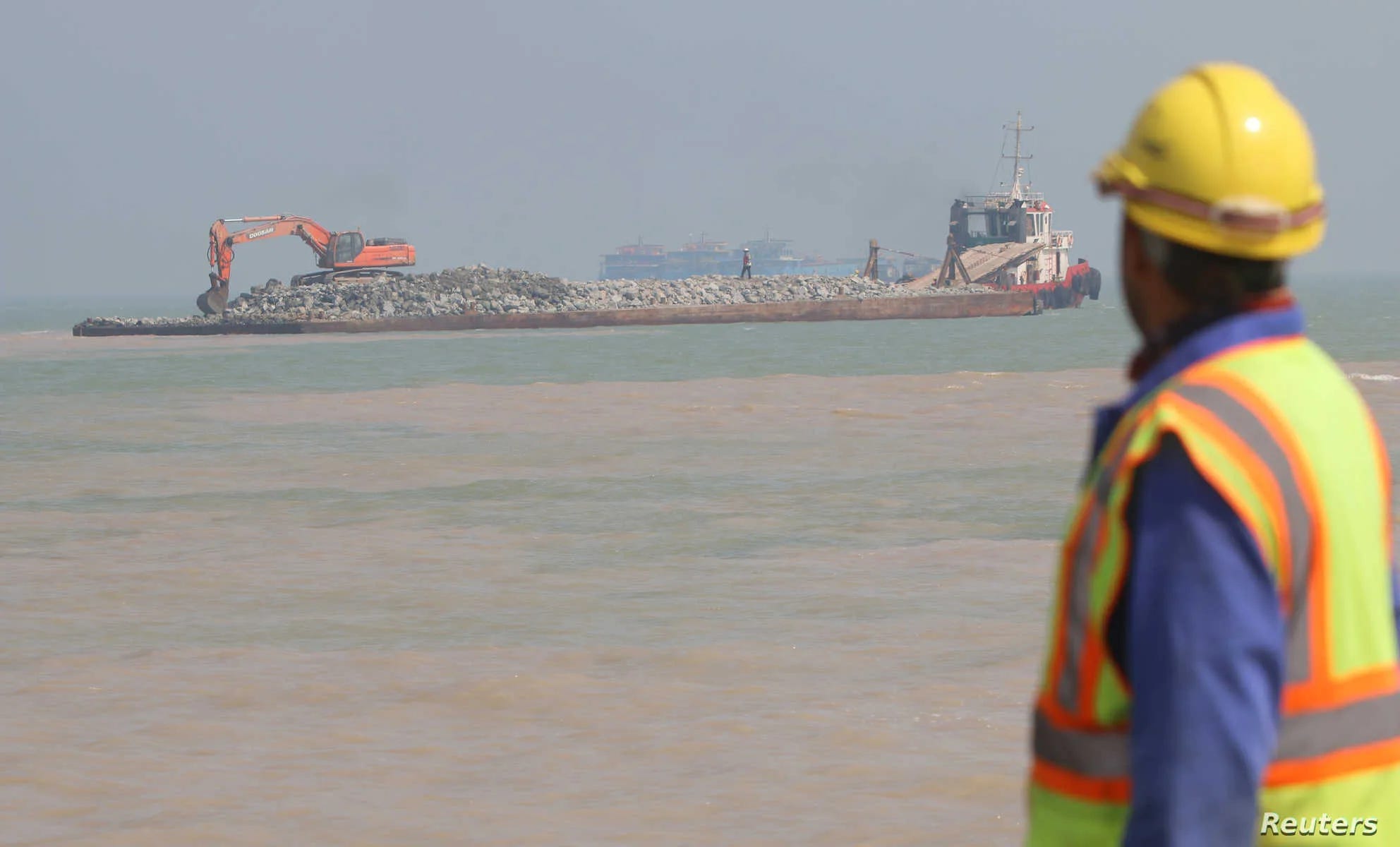
The crisis extends beyond legal language into the core of national economic interests. Iraq’s coastline stretches for only about 58 kilometers and depends entirely on Khor Abdullah as its sole direct maritime outlet to the Gulf and international waters.
This narrow channel, which forms the natural boundary with Kuwait’s Bubiyan Island before emptying into the Gulf, suffers from shallow waters and silt buildup, requiring constant dredging for large commercial vessels. It is therefore the primary artery for the Grand Faw Port project and the strategic Development Road initiative, through which Iraq aims to link Gulf markets to Europe via Turkey.
Iraqi policymakers fear that Kuwaiti expansion and maritime platforms at Fasht Al-Aij could narrow the navigational channel and hinder vessels bound for Iraqi ports.
For its part, Kuwait is developing Mubarak Al-Kabeer Port on neighboring Bubiyan Island as part of its “Kuwait Vision 2035.” Backed by Chinese firms, the Gulf state seeks to establish a new logistics system linking the port to Gulf railway networks.

2. Domestic Politics and Regional Dynamics
In Iraq, the issue is intertwined with internal polarization. The Federal Supreme Court has faced accusations of politicization, while some lawmakers have leveraged the dispute to rally electoral support particularly in Basra, where nationalist sentiment runs high.
Some of those challenging the agreement are reportedly linked to Iran-aligned factions, raising Gulf concerns that regional agendas may be driving the dispute.
Iraq’s submission of the maps triggered immediate regional alert, with repercussions extending beyond bilateral ties. Gulf Cooperation Council states declared full solidarity with Kuwait.
In this context, Saudi Arabia’s stance introduced a new dimension to the crisis. Riyadh warned that the Iraqi coordinates encompass large parts of the submerged divided zone adjacent to the Saudi–Kuwaiti border—an area of acute sensitivity because it includes the Al-Durra natural gas field, in which Saudi Arabia and Kuwait claim exclusive rights to natural resources, while Iran asserts competing claims.