

As the U.S.-Israeli war on Iran enters its second week and regional repercussions intensify following Hezbollah’s direct involvement in the fighting, the Litani River has once again moved to the forefront of both the military and political landscapes. It has become a pivotal axis in Tel Aviv’s strategic calculations.
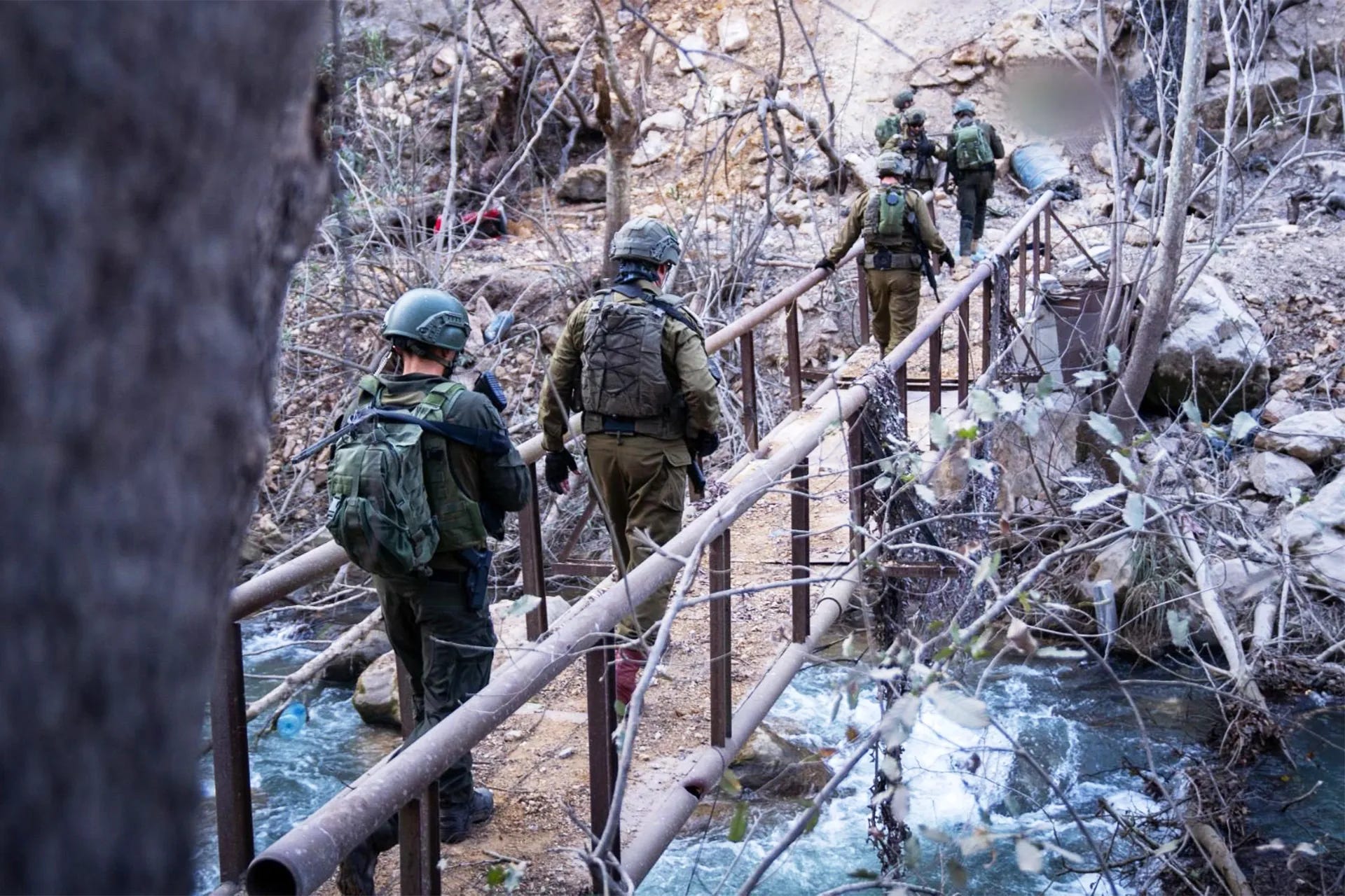
The Israeli army has significantly increased the issuance of urgent and open-ended evacuation warnings to more than 100 towns and villages located south of the river, forcing hundreds of thousands of residents northward in an unprecedented wave of mass displacement.
This escalation is not merely a temporary battlefield tactic or an emotional response to rocket fire. Rather, it reveals a deliberate trajectory aimed at severing this geographical area from its Lebanese surroundings. This raises a central question: Why is Israel so determined to control this particular region?
1. A Strategic Asset
The Litani River is not merely a watercourse flowing through Lebanese territory. It is a strategic asset and a dividing line that reshapes the geography of southern Lebanon.
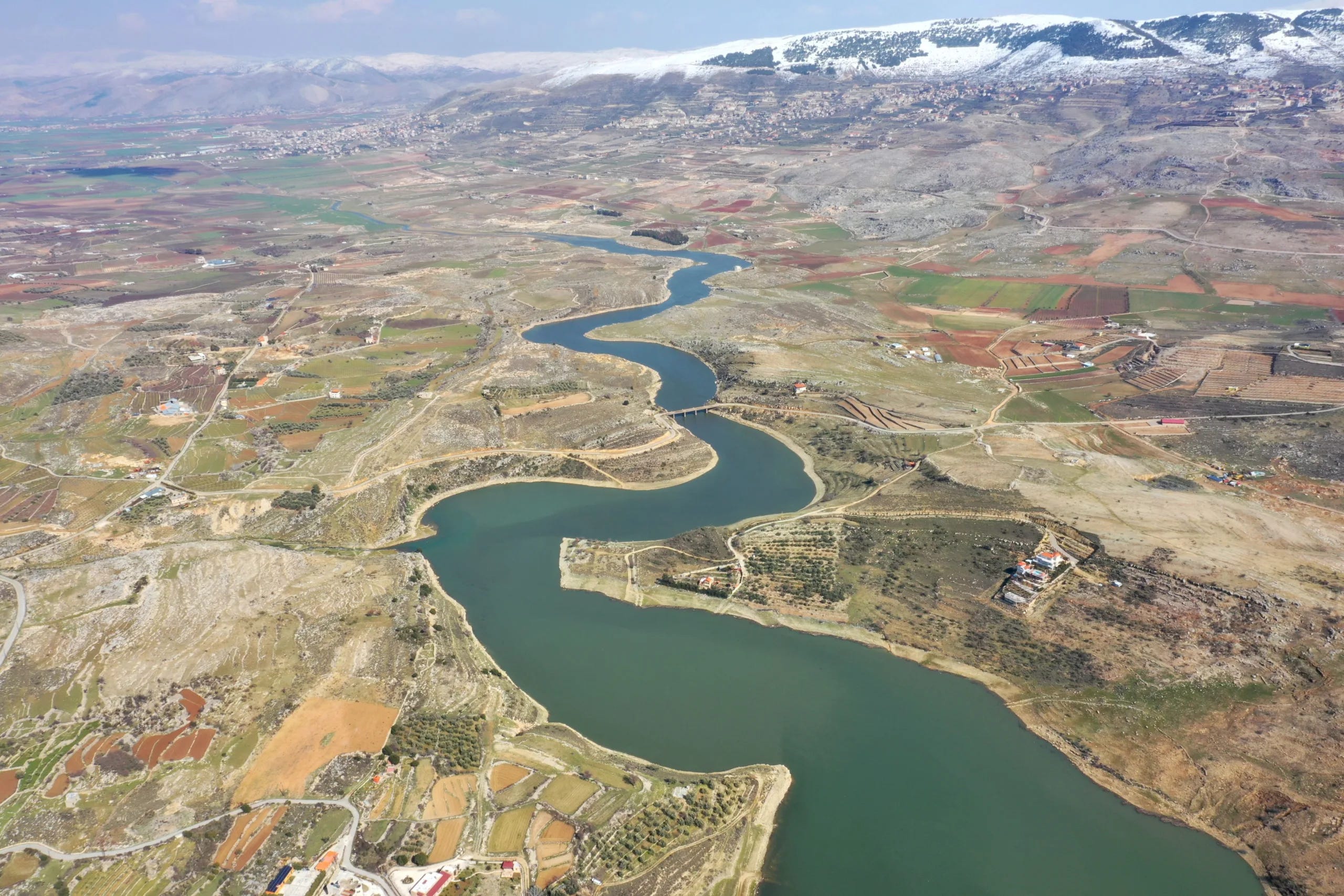
The river originates from the Al-‘Aliq springs west of the city of Baalbek at an elevation of around 1,000 meters. It cuts through the Bekaa Valley from north to south before sharply turning west near the Marjayoun region, carving its way through Lebanon’s mountains until it reaches the Mediterranean Sea north of the city of Tyre.
Stretching roughly 140 kilometers, the Litani is Lebanon’s longest and most water-rich river. It is also unique in that it is entirely national both its source and outlet lie within Lebanese borders meaning that under international water law it is not classified as a transboundary river whose waters neighboring states can legally claim to share.
The Litani basin covers approximately 1,940 to 2,170 square kilometers around 20 percent of Lebanon’s total land area and drains roughly 24 percent of the country’s net rainfall.
This unique configuration has made it, in the words of many analysts, “the key to Lebanon’s future.” The river links vast water resources with a sensitive geopolitical location that effectively separates the south from the rest of Lebanon’s geography.
It therefore serves as a potential launching pad for development projects. Conversely, it can also become a central target for any project of domination.
2. A Lifeline
The Litani represents Lebanon’s economic and hydrological lifeline, making it a highly valuable target for any power seeking comprehensive control over the south.
The river provides drinking water and irrigation for a vast population spread across 263 towns and villages. It also plays a crucial role in electricity generation through the Qaraoun Dam and Lake Qaraoun, which store around 220 million cubic meters of water.
Major infrastructure projects such as the Qasimiya irrigation project and the 800-meter elevation project depend on its waters to supply more than 6,000 hectares of agricultural land and fertile orchards across the Bekaa Valley and southern Lebanon.
Israel recognized this value early on. Structurally, it faces recurring water shortages and has historically relied on resources taken from Arab territories.
To achieve its objectives, Israel has repeatedly targeted the river’s facilities during various phases of conflict, striking water diversion canals and pumping stations in a clear effort to prevent Lebanon from utilizing its own resources. Such attacks undermine Lebanon’s food security and weaken the economic resilience of southern communities.
Choking off these resources becomes a strategic pressure tool that pushes residents toward forced migration and facilitates the demographic emptying of the region.
This dynamic also aligns with Israeli ambitions to benefit from Litani waters as a strategic alternative—or supplement—to water sources in the West Bank and the Golan Heights. Diverting Litani waters could increase Israel’s water resources by as much as 50 percent.
3. A Military Trench
The Litani’s deadly strategic brilliance lies in its terrain. Its course especially the western section known as the Qasimiya River forms a decisive geographical line and a highly complex natural barrier.
The river runs roughly parallel to Lebanon’s border with occupied Palestine, at a distance of about 29 to 30 kilometers to the north.
What makes this line exceptionally valuable in military calculations is the dramatic depth of its valleys. The Litani carves its channel through deep rocky gorges that reach depths of around 275 meters (900 feet) in some areas.
This harsh natural trench separates roughly 850 square kilometers of land south of the river from the rest of Lebanon to the north, limiting the ability of attacking forces to maneuver freely or advance rapidly.
As a result, controlling—or even dominating by firepower—the southern bank of the river effectively means controlling the mandatory crossing routes and isolating southern Lebanon militarily. This transforms the region into a closed pocket that can be encircled with minimal human cost for invading forces.
Past wars between Israel and Lebanon have shown that controlling or crossing the river is far from easy. During the July 2006 war, Israeli forces sought to push Hezbollah fighters beyond the Litani but delayed launching a large-scale ground offensive and only reached the river in the final days of the war.
At that point, their forces had to move through predictable routes due to the deep valleys, exposing them to heavy ambushes. Attempts to block withdrawal routes also failed; the terrain and limited time prevented Israeli troops from sealing every passage, allowing Hezbollah fighters to retreat northward.
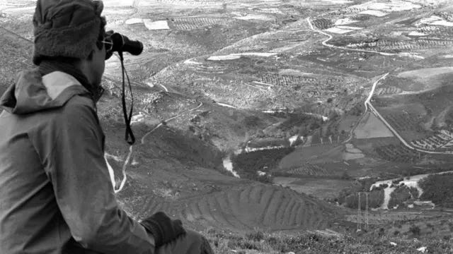
These experiences led Israeli military planners to acknowledge that any invasion of southern Lebanon would face severe geographic complications that favor defenders. This reality helps explain why Israel views the river line as the maximum limit of its ground ambitions seeking to use it as a natural shield that protects its forces from open confrontation.
In the current escalation, the Israeli army is operating under a strategy it calls “deep forward defense,” aiming to transform the villages stretching from the border to the Litani into a zone of widespread destruction in order to raise the cost for Hezbollah and deny it launching points.
Israel’s Historical Obsession With the Litani
The Litani’s place in Israeli strategic thinking is not new. It reflects a long-standing fixation oscillating between ambitions to seize its waters and concepts of military expansion into what Israeli discourse calls the “northern Galilee.”
1943: The Jewish Agency established a water research office that included a Litani unit.
1946: A U.S. agricultural mission visited Lebanon and produced a detailed report on the Litani.
1949: The United Nations’ Clapp Mission issued proposals on the Lebanese economy and described the Litani River as “the key to Lebanon’s future.”
Early 1950s: Zionist planners discussed the possibility of annexing the river or diverting part of its waters to occupied Palestine.
1954: American engineer John Cotton proposed a plan to dig a 100-kilometer canal to redirect the Litani through its valleys into Israel an idea that would require full military control of southern Lebanon.
1982 War: Israel invaded Lebanon and reached Beirut. It later established a “security zone” along the southern border, occupying it until 2000.
One interpretation of the invasion was that it aimed to gather hydrological data from the Qaraoun Dam. Research sources reported that Israeli forces seized river survey data and transported equipment from the Litani Water Authority.
American media reports in the 1980s also noted that Israeli officials viewed diverting part of the river’s water as a way to increase their country’s water resources by between 25 and 45 percent.
Although these plans largely remained aspirational due to political and technical constraints, the river has continued to appear in strategic literature as both a security depth preventing Hezbollah fighters from deploying at close range and a potential additional water source for Israel in the long term.
In the current confrontation, Israel appears to be pursuing a scorched-earth strategy around the Litani to prepare an advanced ground theater of operations transforming the river’s southern bank into a depopulated free-fire zone. Such a move could compensate for intelligence and battlefield shortcomings in confronting rockets and drones.